CSI 2.0 and CLASS
Stations File
The position of the recording sensor is a key element of any seismological application.
More than one sensor can be installed close to each other that typically pertain to the same "site".
The SEED Channel naming convention allows to distinguish different sensors of the same seismic site (namely the same seismic station) based on the sensor characteristics, while the "site" coordinates remain the same within a certain small distance of the sensors themselves (that can be not zero). Moreover, citing the ISC International Registry of Seismograph Stations: "Because of the need for accurate station positions for hypocenter location programs, a new international code is assigned if a station is moved more than one (1) kilometer from the previous location. If the move is less than one (1) kilometer, a new code will be assigned if requested by the operator. Because of its importance for relocation studies of historic earthquakes, it is requested that operators notify international centers whenever a station is moved. It is also important to know the date that the move occurred. An attempt has been made in this publication to indicate that a station has been moved without having a new station code assigned by including a comment. However, there has been no exhaustive search of historic station locations to ensure that all stations which have moved have a comment stating that fact. If a new station position is obtained because of a more accurate survey, without the station being physically relocated, the coordinates will be changed in the station record, but a new code will not be assigned".
The Italian national seismic network has so much evolved in time, since 1980, both in terms of networks handling, network integrations, international code naming, coordinates precision and stations names themselves that often changed in time, that each bulletin came with its own set of stations and sometimes P- and S-phase reading overlap.
This can create problems to the users in using the data.
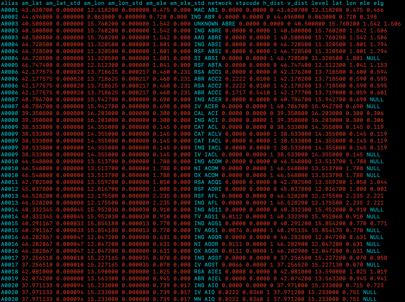
For this reason we first build a complete list of stations names and related coordinates used in the CSI 2.0 and CLASS datasets, and then we run a colocation check to find those network/stations that are essentially the same site in changing name and coordinate precision in time. We then run a statistic analysis getting a standard deviation and a mean for longitude, latitude and depth and, finally attributed these values to a common alias. So in the following downloadable file you will find 1 or more lines with the same alias and the same mean coordinates and standard deviations, corresponding to different "stations and networks names".
These aliases are exactly the same reported in the phases files 1981-2008.
